Columbia sits at the confluence of the Saluda and Broad rivers, which merge to form the Congaree River at the city’s western edge. South Carolina’s capital and largest city draws its drinking water from these river systems, treating water at facilities serving approximately 380,000 customers in the Midlands region.
Lake Murray and the Saluda River System
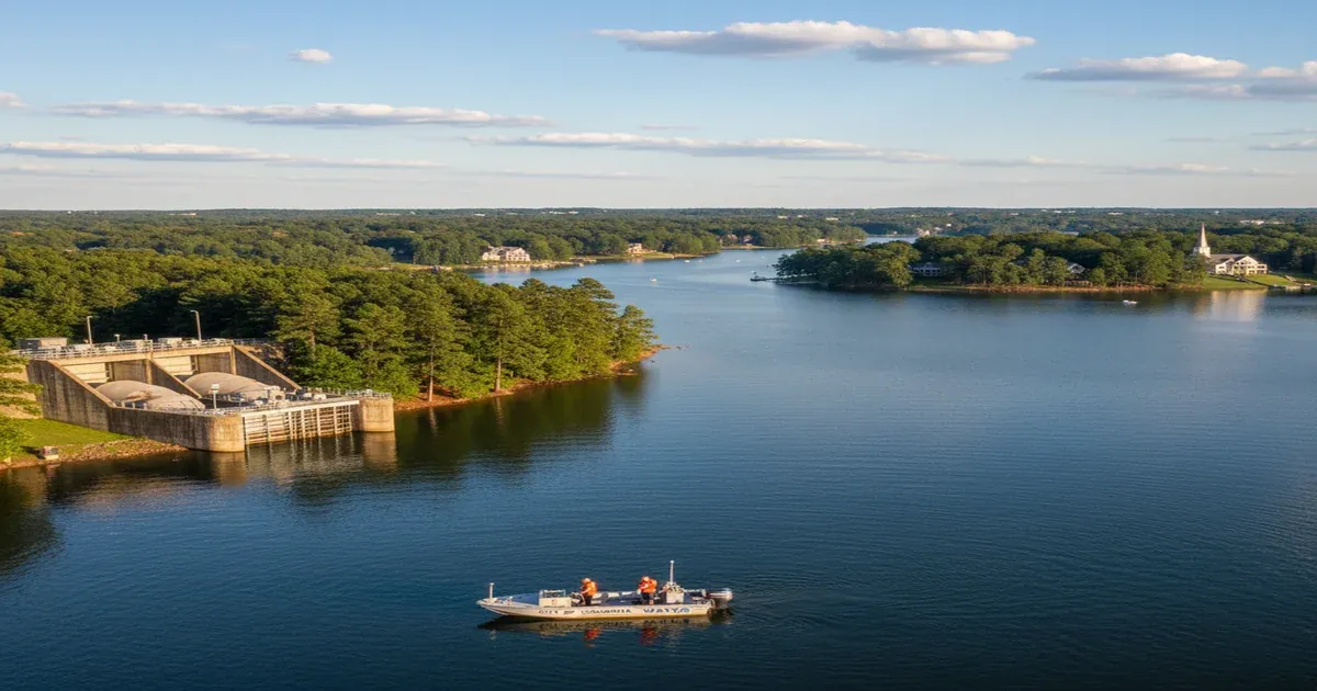
Columbia Water’s primary source is the Saluda River above Lake Murray — an 80,000-acre reservoir created in 1930 by the Dreher Shoals Dam. Lake Murray is one of South Carolina’s largest lakes and has a watershed covering over 2,000 square miles of the Piedmont.
The Saluda River above Lake Murray drains a mixed landscape of forests, rural residential areas, and some agricultural land. Compared to heavily agricultural Midwestern river basins, the Saluda’s watershed is relatively protected — the Piedmont forests filter runoff reasonably well. The reservoir itself provides additional settling time before water is withdrawn.
Columbia Water also operates a direct withdrawal from the Broad River as a secondary source and emergency backup. The Broad River has a more industrial past — the Catawba-Wateree basin upstream in North Carolina has several documented contamination sites — but serves as a reliable supplemental source.
Textile Industry Legacy
South Carolina’s Piedmont was the heart of the American textile industry for most of the 20th century. Mills dotted every river valley, and their effluent — dyes, sizing chemicals, acids, and heavy metals — flowed directly into the waterways that Columbia now relies on.
Most of the major textile mills have closed since the 1990s and 2000s, but their legacy persists in river sediments and, in some cases, groundwater near former mill sites. Chromium, lead, mercury, and persistent organic chemicals from dye operations have been documented at former textile site cleanup locations across the Carolinas.
The South Carolina Department of Health and Environmental Control (DHEC) maintains a Brownfields program for redeveloping former industrial sites, and several former mill properties along the Saluda and Broad rivers have been or are being remediated.
Savannah River Site: A Nuclear Neighbor
The Savannah River Site (SRS) — a former nuclear weapons production complex — is located about 100 miles southwest of Columbia in Aiken County. During Cold War production, the site released radioactive materials into the Savannah River and contaminated soil and groundwater across a 310-square-mile federal reservation.
SRS is the most contaminated nuclear site on the East Coast by some measures, and the Department of Energy’s cleanup program has been ongoing since the 1990s. While the Savannah River drains south toward Augusta and Savannah rather than toward Columbia, the contamination from SRS has historically included tritium, cesium, strontium-90, and various volatile organic compounds in groundwater.
Columbia’s drinking water sources — the Saluda and Broad rivers — aren’t directly in the SRS drainage basin. But the proximity of such a significant nuclear facility shapes the regional contamination awareness. DHEC monitors Columbia Water’s source water comprehensively, including for radionuclides.
Military PFAS: Fort Jackson
Fort Jackson, the Army’s largest basic training installation, sits squarely within Columbia’s metro area — it occupies over 52,000 acres in Richland County. Like virtually all major military installations, Fort Jackson has a history of AFFF use for firefighting training and emergency response.
DHEC and the Army have conducted PFAS sampling around Fort Jackson. PFAS contamination has been detected in groundwater monitoring wells on and near the installation. The contamination plume dynamics and potential for migration toward municipal water sources or residential wells in the surrounding area are under investigation.
Columbia Water samples its finished water for PFAS, and levels have been below the EPA’s 2024 MCLs. But the proximity of Fort Jackson to the city and its water infrastructure makes this an area of ongoing watchfulness.
Growing Pains and Water Infrastructure
Columbia’s metro area has been growing steadily, and suburban expansion across Richland and Lexington counties has increased impervious surface in the Lake Murray and Broad River watersheds. Stormwater runoff from new development carries sediment, petroleum, lawn chemicals, and fertilizers into the river system.
Lead service lines in the city’s older neighborhoods — particularly in the historic neighborhoods of North Columbia and the areas around the University of South Carolina — remain a concern. Columbia Water has been working on lead service line identification and corrosion control.
What Columbia Residents Can Do
Columbia’s water supply starts from relatively good source water. The key risks are lead in older homes and PFAS from military sources:
- Test for lead if your home was built before 1986 — contact Columbia Water for testing guidance.
- Monitor PFAS updates — as Fort Jackson’s PFAS investigation develops, watch for updates from DHEC and Columbia Water.
- Private well users near Fort Jackson or former mill sites should test for PFAS and VOCs.
- Review the annual CCR — Columbia Water publishes detailed water quality information.
If you’re concerned about your water quality, a certified water treatment professional can help you test your water and recommend the right solution for your home.