A City Between the Water and the Sea
Norfolk sits at the mouth of the Chesapeake Bay, surrounded by water on three sides. The city’s 245,000 residents get their drinking water from the Norfolk Department of Utilities, which operates two water treatment plants drawing primarily from Lake Prince and the Western Branch of the Nansemond River — surface water sources located about 30 miles west of the city in Suffolk.
These sources were chosen decades ago specifically because they were far from the saltwater influence of the Chesapeake Bay and Atlantic Ocean. But as sea levels rise and saltwater pushes further up Virginia’s tidal rivers, the buffer distance is shrinking.
Sea Level Rise: The Existential Water Threat
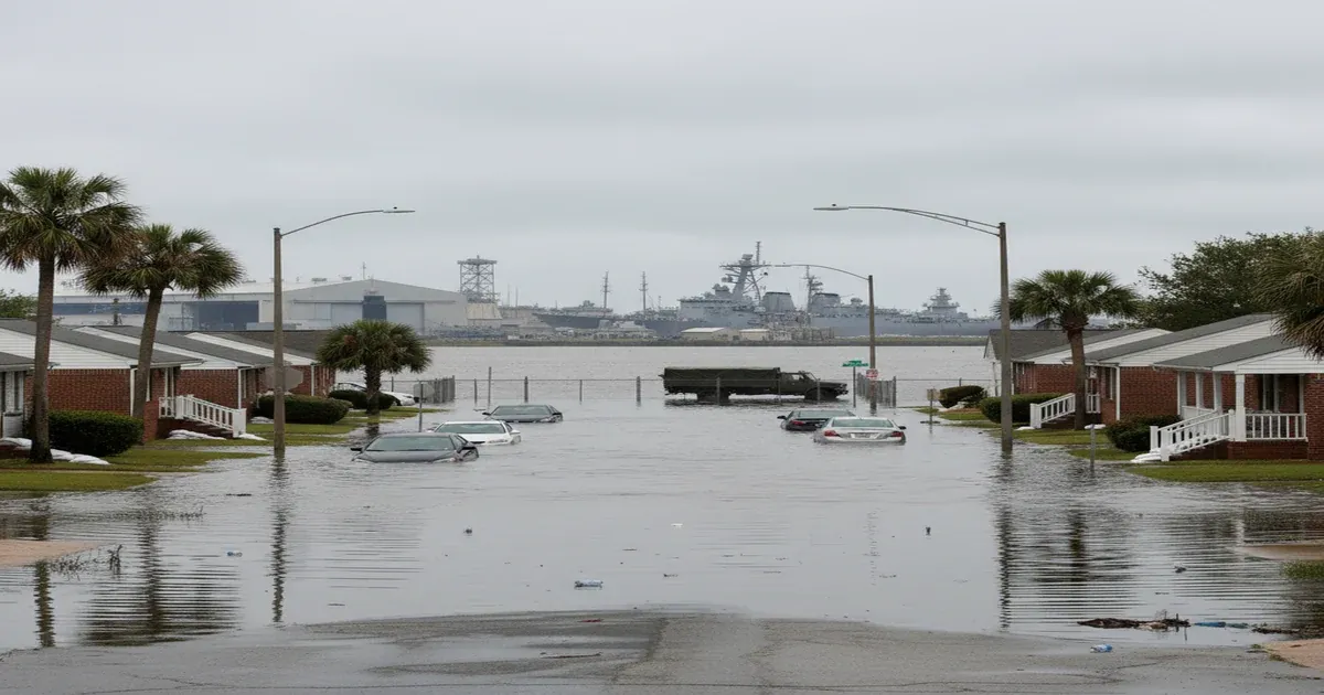
Norfolk is one of the fastest-sinking and fastest-flooding — facing flooding pressure alongside cities like Miami — cities in the United States. The combination of land subsidence (the ground is literally sinking) and sea level rise means that relative sea level in Norfolk has risen about 18 inches since 1930 — one of the highest rates on the East Coast.
For drinking water, this creates several concerns:
- Saltwater intrusion into groundwater — the shallow aquifer beneath Norfolk and Hampton Roads is increasingly contaminated by saltwater, affecting any remaining private wells and limiting future groundwater development
- Flooding of water infrastructure — pump stations, treatment plants, and distribution system components in low-lying areas are vulnerable to tidal flooding and storm surge
- Source water vulnerability — while Norfolk’s surface water sources are inland, rising seas push saltwater further up the James River and its tributaries, potentially affecting water quality at intake points over the coming decades
- Stormwater contamination — frequent flooding washes contaminants (sewage, chemicals, sediment) into waterways that may eventually reach water supply sources
Norfolk’s Coastal Resilience Strategy has identified water infrastructure as a critical vulnerability, and the city is investing in flood protection, infrastructure elevation, and system hardening.
Naval Station Norfolk: PFAS and Military Contamination
Norfolk is home to Naval Station Norfolk — the largest naval base in the world — along with multiple other military installations including Naval Air Station Oceana (in neighboring Virginia Beach), Joint Expeditionary Base Little Creek, and Norfolk Naval Shipyard.
The military presence brings economic vitality but also contamination legacy:
- PFAS from AFFF — decades of firefighting foam use at military airfields and shipyards has contaminated groundwater with PFOS, PFOA, and other PFAS compounds. The Department of Defense has acknowledged PFAS contamination at multiple Hampton Roads installations and is conducting investigations
- Industrial contamination — ship maintenance, fuel storage, and industrial operations at naval facilities have created contamination plumes involving petroleum compounds, heavy metals, and solvents
- Superfund sites — several military-related Superfund sites exist in the Hampton Roads area, with ongoing remediation
The PFAS contamination is particularly concerning because of the proximity to drinking water sources and the large population potentially affected. Virginia Beach faces similar military PFAS challenges from NAS Oceana.
Lead and Aging Infrastructure
Norfolk’s water distribution system includes infrastructure dating back to the early 1900s. The city has a mix of pipe materials, and lead service lines remain in some older neighborhoods — particularly in the Ghent, Colonial Place, Park Place, and Huntersville areas.
The utility uses optimized corrosion control treatment and has met the EPA’s action level for lead at the 90th percentile. Norfolk’s lead service line inventory is underway per the EPA’s revised Lead and Copper Rule requirements.
As with other older cities, water main breaks are a recurring issue. Salt air and the coastal environment accelerate corrosion of metal pipes, and the high water table makes underground repairs more challenging.
Disinfection and DBPs
Norfolk’s treatment plants use conventional treatment with chloramine for secondary disinfection. The surface water sources carry moderate organic matter from the forested and agricultural watersheds around Lake Prince and the Nansemond River.
Disinfection byproduct levels are managed within EPA limits, but seasonal variations in source water quality can cause fluctuations. The utility monitors TTHMs and HAAs closely and adjusts treatment to maintain compliance.
The Chesapeake Bay Connection
Norfolk’s water quality story can’t be separated from the broader Chesapeake Bay ecosystem. The Bay has been the focus of a decades-long restoration effort to address nutrient pollution (nitrogen and phosphorus), sediment, and toxic contamination from agriculture, urban runoff, and wastewater discharges.
While Norfolk’s drinking water comes from sources upstream of the Bay’s tidal influence, the health of the Chesapeake ecosystem affects everything from recreational water quality to the long-term viability of the region’s water resources.
What Residents Can Do
- Review Norfolk’s annual Water Quality Report for current contaminant data and treatment information
- For older homes, flush the tap for 30 seconds to 2 minutes before drinking, especially in the morning
- Consider a certified water filter — NSF/ANSI 53 for lead reduction, NSF P473 for PFAS, activated carbon for taste and DBPs
- If you’re on a private well in the Hampton Roads area, test annually for bacteria, nitrates, chloride (saltwater intrusion), and consider PFAS testing if near military installations
- Prepare for water disruptions — Norfolk’s flood vulnerability means boil water advisories and service interruptions can occur during major storm events. Keep emergency water on hand
- Stay informed about military PFAS investigations — the Department of Defense publishes updates on remediation at Norfolk-area installations
If you’re concerned about your water quality, a certified water treatment professional can test your water and recommend solutions appropriate for Norfolk’s specific challenges.
Sources
- City of Norfolk Department of Utilities, Annual Water Quality Reports
- Hampton Roads Planning District Commission, Coastal Resilience Strategy
- U.S. Navy, Environmental Restoration at Hampton Roads Installations
- Virginia Department of Health, Drinking Water Program
- EPA SDWIS, Norfolk water system compliance records
- Chesapeake Bay Foundation, Water Quality Monitoring Data